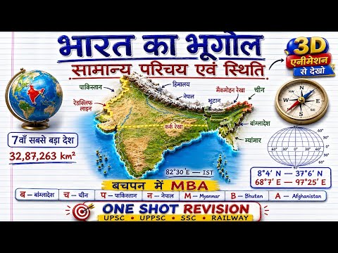
Summary
This video presents a comprehensive, topic-wise approach to Indian Geography, designed for competitive exams. It covers syllabus details, planning around 30 detailed video lectures, and aims to make complex topics accessible. The presenter emphasizes a high-quality, free educational resource, focusing on detailed analysis of MCQs and comprehensive coverage of Indian Geography from its basic introduction to advanced topics like resources, transport, and demographics, suitable for learners of all levels from school to civil services.
Key Insights
Master mapping and notes are unnecessary after this series.
The presenter assures viewers that they will master mapping skills and no longer need to consult notes or books after completing this series. The content is structured to be so effective that it will entirely replace the need for external study materials.
A unique teaching methodology is promised, making learning engaging.
The presenter expresses confidence that viewers will find the teaching style highly engaging and effective, predicting that learners will wish they had encountered this method earlier in their preparation, potentially leading to earlier selection.
Explains the strategic importance of the Siliguri Corridor (Chicken's Neck).
This narrow corridor is crucial for connecting mainland India to its northeastern states. It's strategically vital as it's narrow and borders multiple countries, making it a point of geopolitical interest and potential vulnerability.
Defines the Line of Actual Control (LAC) between India and China.
The LAC is the de facto border separating Indian-controlled territory from Chinese-controlled territory (Aksai Chin) following the 1962 Sino-Indian War. It is distinct from the Line of Control (LOC).
The Chumbi Valley is a tri-junction point between India, Bhutan, and China.
This valley is strategically significant as it borders these three nations, making it a sensitive geopolitical area, particularly in relation to the Doklam Plateau dispute.
Gujarat is the only Indian state to share both land and maritime borders with Pakistan.
Gujarat's coastline forms part of the maritime border, while its northernmost tip touches the land border with Pakistan, making it unique in this regard.
Ladakh shares the longest border with China among Indian territories.
As a Union Territory, Ladakh's vast geographical area and its northern position give it the longest border segment with China.
Sections
Introduction to the Indian Geography Series
A comprehensive 'one-shot' approach to Indian Geography for competitive exams.
This series is designed as a golden opportunity for students who find Indian Geography and mapping challenging. It promises to be an 'A to Z' resource for all competitive exams, including state PCS, police exams, TGT, PGT, and LT exams, where Indian Geography is a part of the syllabus. The focus is on minimizing mistakes in questions by providing a strong understanding.
1400 questions analyzed to cover 8400 concepts in 24 hours.
The series is built upon 1400 meticulously selected questions, which upon detailed analysis, cover as many as 8400 sub-concepts. The aim is to enable students to complete the entire Indian Geography syllabus in approximately 24 hours by watching these videos, potentially at 2x speed. A PDF will also be provided.
Master mapping and notes are unnecessary after this series.
The presenter assures viewers that they will master mapping skills and no longer need to consult notes or books after completing this series. The content is structured to be so effective that it will entirely replace the need for external study materials.
The series is structured topic-wise for clarity and ease of learning.
The lectures are organized topic-wise, ensuring that questions are presented logically according to their subject matter. This approach prevents confusion and aids in better comprehension compared to random question sequencing.
All classes merged into topic-wise videos for a cohesive learning experience.
The presenter explains that the content is not a single long video but rather a compilation of all relevant classes merged topic-wise. This ensures a structured and comprehensive learning path for each subject area.
A unique teaching methodology is promised, making learning engaging.
The presenter expresses confidence that viewers will find the teaching style highly engaging and effective, predicting that learners will wish they had encountered this method earlier in their preparation, potentially leading to earlier selection.
The series provides a structured syllabus of 30 planned video lectures.
The presenter outlines a detailed plan covering approximately 30 video lectures, meticulously covering all aspects of Indian Geography. The syllabus includes topics like general introduction, mountains, passes, glaciers, plateaus, coastal areas, islands, states, rivers, waterfalls, lakes, climate, natural disasters, soil, vegetation, irrigation, dams, agriculture, mineral resources, power, industries, transport, population, and miscellaneous topics.
Content covers multiple exam levels from RAH to NDA and Police.
The questions and explanations are designed to be relevant for a wide range of exams, including RAH, PCS, SSC CGL, ROR, LT, TGT, Police, and SI, ensuring comprehensive preparation for diverse competitive tests.
Free, high-quality content including PDFs is provided.
The entire series, including detailed explanations and supplementary PDFs, is offered completely free of charge. This contrasts with paid courses, highlighting the presenter's commitment to accessible education.
A daily schedule of 3 classes: 10 AM (Polity), 4 PM (Geography), 8 PM (Current Affairs).
The presenter outlines a consistent daily class schedule: Polity at 10 AM, Geography at 4 PM, and Current Affairs at 8 PM. This schedule offers a structured learning routine for students.
History will be introduced after the completion of current affairs.
Following the completion of the current affairs segment, a new series on History will be launched, further expanding the free educational offerings.
The goal is to complete the entire GK/GS syllabus, including Static GK, in 60 days.
The presenter has set an ambitious target to cover the entire General Knowledge and General Studies syllabus, along with Static GK, within a 60-day timeframe.
India's Location and Extent (Part 1 & 2)
This is the second part of the series on India's introduction and extent.
This video is part two of the 'India's Introduction' topic, following up on a previous session where 40 questions were covered. The current session aims to complete the topic by discussing remaining questions and clearing any doubts.
Clarification on the number of international border states and UTs.
The presenter clarifies that 18 entities share international borders, including 16 states and 2 Union Territories (Jammu & Kashmir and Ladakh). This addresses a viewer's query.
Correction on the 3rd largest country by area: USA vs. China.
The presenter corrects a potential misconception regarding the world's third-largest country by area, reaffirming that the USA is third, not China, based on Wikipedia data and area comparison, despite Google searches sometimes showing China.
Identifies three Indian states bordering two different countries.
Uttarakhand borders China and Nepal. Assam borders Bhutan and Bangladesh. Mizoram borders Myanmar and Bangladesh. These are the only three states sharing borders with two separate countries.
Lists the top 5 Indian states by area and their ranking.
Rajasthan is the largest, followed by Madhya Pradesh, Maharashtra, Uttar Pradesh, and Gujarat.
Lists Indian states by area from smallest to largest.
Goa is the smallest, followed by Sikkim, Tripura, and Nagaland, in ascending order of area.
Lists the largest Union Territories by area.
In descending order of area, the largest UTs are Ladakh, Jammu & Kashmir, and Andaman & Nicobar Islands.
Lists the smallest Union Territories by area.
In ascending order of area, the smallest UTs are Lakshadweep, Chandigarh, Puducherry, and Dadra Nagar Haveli and Daman and Diu.
Identifies Andaman and Nicobar Islands as a UT in the Bay of Bengal.
This Union Territory is situated in the Bay of Bengal, distinct from territories in the Arabian Sea.
Explains the strategic importance of the Siliguri Corridor (Chicken's Neck).
This narrow corridor is crucial for connecting mainland India to its northeastern states. It's strategically vital as it's narrow and borders multiple countries, making it a point of geopolitical interest and potential vulnerability.
The Great Channel separates India's Great Nicobar from Indonesia's Sumatra.
This channel lies south of India's southernmost tip, Indira Point, and demarcates the boundary between India's territory and that of Indonesia, highlighting India's southern maritime reach.
Telangana is the Indian state that does not share any international border.
Telangana, formed from Andhra Pradesh, is landlocked and does not share borders with any of India's neighboring countries.
There are four Indian Union Territories that have coastlines.
The four UTs with coastlines are Lakshadweep, Andaman & Nicobar Islands, Dadra Nagar Haveli and Daman and Diu, and Puducherry. This highlights their maritime significance.
Defines the Line of Actual Control (LAC) between India and China.
The LAC is the de facto border separating Indian-controlled territory from Chinese-controlled territory (Aksai Chin) following the 1962 Sino-Indian War. It is distinct from the Line of Control (LOC).
Explains the Line of Control (LOC) between India and Pakistan-administered Kashmir.
The LOC is the military control line between Indian-controlled Jammu and Kashmir and Pakistan-administered territories (like POJK). It evolved from the ceasefire line established after the 1947-48 Indo-Pak war.
Details the Sir Creek dispute between India and Pakistan.
Sir Creek is a 96 km long marshy border in Gujarat's Rann of Kutch, disputed between India and Pakistan due to its maritime boundary implications and resource potential.
Thimphu, Bhutan's capital, is the closest foreign capital to India's border.
This highlights Bhutan's geographical proximity to India, and its status as a politically stable neighbor. Bhutan is also recognized for its environmental conservation policies.
Four Indian states share borders with Bhutan: Assam, Arunachal Pradesh, West Bengal, and Sikkim.
Assam shares the longest border, while Sikkim shares the shortest (32 km) with Bhutan. Bhutan is also known as the 'Land of the Thunder Dragon' and is a landlocked country.
Identifies the disputed areas contributing to India-Nepal border tensions.
The Kalapani territory and Susta region are key disputed areas. Kalapani's control is linked to the source of the Kali River (known as Sharda in India), involving India, Nepal, and China and defined by the 1816 Treaty of Suguali. Susta involves the Gandak River's shifting course.
India has two maritime neighbors: Maldives and Sri Lanka.
These countries are India's closest maritime neighbors, distinct from its seven land neighbors. Maldives is known for its atolls, and Sri Lanka is an island nation south of India.
Explains the concept of India's Exclusive Economic Zone (EEZ).
The EEZ extends up to 200 nautical miles from India's baseline, granting sovereign rights over exploring and utilizing resources within this zone. This is a critical aspect of India's maritime law.
The EEZ concept applies to territorial waters and contiguous zones.
The presenter clarifies the three maritime zones: Territorial Sea (12 nm), Contiguous Zone (24 nm), and Exclusive Economic Zone (200 nm), each with distinct rights for the coastal state.
France has the largest EEZ globally due to its overseas territories.
This is attributed to France's numerous islands and territories worldwide, giving it a vast maritime jurisdiction compared to other nations like the USA, Australia, and Russia.
Uttar Pradesh shares the longest border with Nepal among Indian states.
UP shares approximately 651 km of border with Nepal. West Bengal shares the shortest border (approx. 96 km).
The territorial sea extends up to 12 nautical miles from India's coast.
This zone represents India's sovereign waters, similar to its land territory, and is the first of the three maritime zones.
Sikkim shares the shortest border with Bhutan among Indian states bordering Bhutan.
Sikkim's border with Bhutan is approximately 32 km, the shortest among the four states (Assam, Arunachal Pradesh, West Bengal, Sikkim) that share a border with Bhutan.
The Chumbi Valley is a tri-junction point between India, Bhutan, and China.
This valley is strategically significant as it borders these three nations, making it a sensitive geopolitical area, particularly in relation to the Doklam Plateau dispute.
The eastern border between India and Nepal is primarily marked by the Mechi River.
The Mechi River originates in the Mahabharat Range in Nepal, flows into Bihar, India, and merges with the Mahananda River, an eastern tributary of the Ganges.
The Coco Channel is a disputed island/waterway between India and Myanmar.
This channel lies south of the north-eastern Indian coast and north of Myanmar's Irrawaddy delta, and is a point of geopolitical contention, especially concerning naval access.
India's land border with Bangladesh is approximately 4096.7 km long.
This is India's longest international land border, shared with Bangladesh, which touches five Indian states: West Bengal, Assam, Meghalaya, Tripura, and Mizoram.
India's land border with China is approximately 3488 km long.
This border stretches across five Indian states/UTs: Ladakh, Himachal Pradesh, Uttarakhand, Sikkim, and Arunachal Pradesh, and is characterized by the McMahon Line and LAC.
India's land border with Pakistan is approximately 3323 km long.
This border is divided into the Radcliffe Line in the west and the LOC in the northern sector, touching four Indian states/UTs: Gujarat, Rajasthan, Punjab, and Jammu & Kashmir.
India's land border with Nepal is approximately 1751 km long.
This open border is shared with five Indian states: Uttarakhand, Uttar Pradesh, Bihar, West Bengal, and Sikkim, and is primarily defined by rivers like Kali and Kosi.
India's land border with Myanmar is approximately 1643 km long.
This border passes through four Indian states: Arunachal Pradesh, Nagaland, Manipur, and Mizoram, marked by mountain ranges and dense forests.
India's land border with Bhutan is approximately 699 km long.
This border is shared with four Indian states: Sikkim, West Bengal, Assam, and Arunachal Pradesh, and Bhutan is known for its strict environmental policies.
India's land border with Afghanistan is the shortest at approximately 106 km.
This border is entirely within the Union Territory of Ladakh and is a strategically sensitive region due to its proximity to Central Asia.
The total length of India's land borders is approximately 15,106.7 km.
This figure aggregates the land borders shared with Pakistan, Afghanistan, China, Nepal, Bhutan, Myanmar, and Bangladesh, illustrating the vastness of India's frontier.
Gujarat is the only Indian state to share both land and maritime borders with Pakistan.
Gujarat's coastline forms part of the maritime border, while its northernmost tip touches the land border with Pakistan, making it unique in this regard.
Lists the northeastern states bordering Myanmar from North to South.
The order is Arunachal Pradesh, Nagaland, Manipur, and Mizoram, defining the sequence of these states along India's eastern frontier with Myanmar.
Identifies Arunachal Pradesh, Sikkim, and West Bengal as sharing three international borders.
Arunachal Pradesh borders China, Bhutan, and Myanmar. Sikkim borders China, Nepal, and Bhutan. West Bengal borders Bangladesh, Nepal, and Bhutan.
Assam shares borders with two international countries: Bangladesh and Bhutan.
Assam's geographical location allows it to border both Bangladesh to the south and Bhutan to the north, distinguishing it from states bordering three countries.
Identifies cities north of the Tropic of Cancer.
Delhi is located north of the Tropic of Cancer, indicating its higher latitude compared to cities like Gandhinagar or Ranchi, which are closer to or on the Tropic.
The India-China-Myanmar tri-junction is a geopolitically sensitive area.
This specific region, often near the Diphu Pass, is a point of geopolitical contention and strategic importance due to the overlapping territorial claims and interests of the three nations.
Explains the 2-hour time difference between Arunachal Pradesh and Gujarat.
This difference arises from the longitudinal extent of India (approx. 30 degrees), where each degree of longitude corresponds to 4 minutes of time, leading to a 2-hour gap between the easternmost and westernmost points.
The Indian Standard Time (IST) is based on 82.5° East longitude.
This longitude passes through five Indian states: Uttar Pradesh, Madhya Pradesh, Chhattisgarh, Odisha, and Andhra Pradesh, serving as the reference for India's time zone.
India's time zone is 5.5 hours ahead of Greenwich Mean Time (GMT).
This difference is due to Earth's rotation and India's geographical position east of the Prime Meridian. Every 15 degrees east adds one hour.
India's landlocked neighbors are Nepal and Bhutan.
These two countries do not have direct access to the sea, relying on routes through neighboring countries like India for international trade and connectivity.
China's border with India is characterized by the McMahon Line and LAC.
The McMahon Line demarcates the eastern sector, while the Line of Actual Control (LAC) reflects the de facto border in the western and middle sectors, stemming from historical and geopolitical disputes.
The Indian state of Manipur shares a border with Myanmar.
Manipur is one of the northeastern states that shares a significant border with Myanmar, contributing to the shared cultural and geographical landscape.
The Indian states bordering China are Ladakh, Himachal Pradesh, Uttarakhand, Sikkim, and Arunachal Pradesh.
These states and UT form India's northern frontier with China, a border marked by complex terrain and historical disputes.
The Indian states bordering Nepal are Uttarakhand, Uttar Pradesh, Bihar, West Bengal, and Sikkim.
These states constitute India's southern and western frontier with Nepal. Notably, Uttar Pradesh shares a substantial border.
Ladakh shares the longest border with China among Indian territories.
As a Union Territory, Ladakh's vast geographical area and its northern position give it the longest border segment with China.
India's land borders are with 7 countries: Pakistan, Afghanistan, China, Nepal, Bhutan, Myanmar, Bangladesh.
This list details all of India's land neighbors, encompassing a diverse range of geographical and geopolitical relationships.
Ask a Question
*Uses 1 Wisdom coin from your coin balance